Per a suggestion from Skyscrapercity user Sky_Higher, I've created a second version of the EDSA concept signs from Mall of Asia to the Guadalupe Bridge, this time incorporating the route numbering and shields implemented by the Department of Public Works and Highways in 2012.
As EDSA is part of National Highway 1, some of the inherent issues with the Philippine highway numbering system will pop up here.
EDIT, 4/6/21: Changed directions on signage sketches from east/west to north/south, per suggestion from Skyscrapercity user goliath103.
---
Northbound, Mall of Asia to Guadalupe
450 meters east of Mall of Asia
D. Macapagal Boulevard (TO Route E6)
Though this segment is not actually part of the numbered routing along EDSA, it is close enough that signing it for Route 1 east is reasonable.
Route 171 signage for Tramo Street/Aurora Boulevard. As Macapagal points to NAIAX (and thus the best routes to Terminals 2 and 3), the route number for that expressway, E6, is mentioned here.
1 kilometer east of Mall of Asia
between Roxas and Harrison
For the upcoming Magallanes exit, only the road names are mentioned, along with the highway designations (E2 for Skyway and SLEX, Route 145 for Osmena north).
2 kilometers east of Mall of Asia
Taft Avenue
Exit 2, Tramo (Route 171)
Exit 3, Osmena Highway (Route 145)/SLEX and Skyway (Route E2)
Now that Osmena Highway is merely a frontage/feeder road for Skyway, not sure it still merits having its own separate route designation.
Exit 5A, Arnaiz
Control city starts to switch over to Ortigas, the next major destination.
4.6 kilometers east of Mall of Asia
Ayala Tunnel
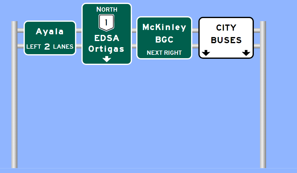
Exit 5B, Ayala/McKinley
First notation of the upcoming Kalayaan Avenue turnoff going to BGC.
Signage at the offramp itself:
Signage at the intersection with Ayala Avenue/McKinley Road:
Exit 6, Kalayaan/Route 190
Exit 7, Estrella Street (no change to sign design here)
7 kilometers east of Mall of Asia
Estrella footbridge
7.6 kilometers east of Mall of AsiaGuadalupe footbridge
Exit 8, Guadalupe/J.P. Rizal
---
Southbound from Guadalupe to Mall of Asia
Exit 8, Guadalupe/J.P. Rizal
7.6 kilometers east of Mall of Asia
In this design iteration, exit has no control destination listed, to save on message loading.
Exit 7, Estrella
The "TO Skyway" sign for the Buendia exit now includes an E2 shield reflecting Skyway's route designation.
Exit 6, Buendia
5.9 kilometers east of Mall of Asia
Exit 5, Ayala/Arnaiz
First mention of the upcoming Magallanes interchange, with shields for both Route E2 (SLEX/Skyway) and Route 145 (Osmena).
4.9 kilometers east of Mall of Asia
Arnaiz overpass
Exit 4B, Pasong Tamo
Exit 4A, Route E2 (SLEX/Skyway)/Route 145 (Osmena Highway to Skyway/Route E2 north)
Ramp fork signage.
The Magallanes interchange brings up the following set of issues in terms of route numbering and even routing in general:
1. As noted above, does Osmena really need to be a numbered route if it is merely a frontage road now for Skyway?
2. Since both Skyway and SLEX are Route E2, no distinction is made between the two roads, even though there are access points that only exist on one or the other. So telling a driver to take "Route E2 south" to get to Lawton Avenue, there is no clarity as to whether to take E2 along Skyway (which has absolutely no access to Lawton) or E2 along SLEX to correctly to get there.
3. The segment of Route 1 along EDSA ends at Roxas, but does not directly connect to link to the next portion of Route 1 (in Alabang). SLEX is the obvious routing there, but is not part of Route 1.
3 kilometers east of Mall of Asia
M. Reyes turnoff (no change from previous design)
Exit 2, Tramo/NAIA (Route 171)
\
2.2 kilometers east of Mall of Asia
Taft Avenue (Route 170)
800 meters east of Mall of Asia
Roxas Boulevard diamond interchange
The route numbering issues that first pop up at Magallanes now come to a head in Bay City, where the logic of the highway designations can easily be seen as questionable.
- Why are Route 120 and Route 61 separated when they are literally the same boulevard? While there are examples of this in the United States (particularly I-880/Route 17 in San Jose and I-980/Route 24 in Oakland), in that case, that is also a type of designation change (state route to interstate) that is not even occurring here.
- As mentioned in the Magallanes section, Route 1's segment end here is discontinuous with the next section of the route in Alabang.
- While the E-series expressway numbering could be analogous to the US Interstate system, there is a legit argument to make CAVITEX and Roxas as a single-number corridor (a setup that would be similar to the US route system in America, i.e. US 101 which can be street at times and freeway at others).
- If EDSA had one number as opposed to piggybacking on Route 1, the entirety of EDSA going to Mall of Asia would fit nicely in that designation. (In fact, EDSA's original number in the 1950s was Route 54.)


Comments
Post a Comment